Arunachal Pradesh Map 2025 - Summary
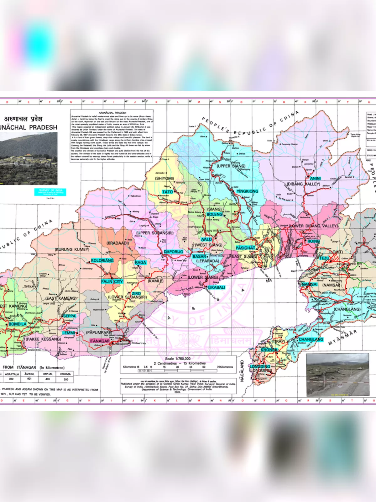
The Arunachal Pradesh Map is a helpful tool to understand the geography and culture of this unique state in northeastern India in 2025. It covers a large area, about 84,000 square kilometers, and shares its borders with countries like Bhutan, China, and Myanmar. Looking at an Arunachal Pradesh map lets you see everything from the very tall, snowy Himalayas in the north to the flat, green plains of the Brahmaputra valley in the south.
Exploring Arunachal Pradesh: A Look at the Map
Arunachal Pradesh is located right at the top-right corner of India. On an Arunachal Pradesh map, you’ll notice it borders the states of Assam and Nagaland in the south. To the west is Bhutan, to the east is Myanmar, and to the north is China, along a line called the McMahon Line. It’s the biggest state in northeast India by land area, even bigger than Assam. The state sits between 26°11’22” to 29°11’22” North of the Earth’s equator and 91°30’22” to 97°30’22” East of the prime meridian.
Main Details from the Arunachal Pradesh Map PDF
Arunachal Pradesh covers a total area of 83,743 square kilometers (about 32,333 square miles). This makes it the 14th largest state in India. On an Arunachal Pradesh map, you’ll see the land shaped by big rivers like the Brahmaputra, Subansiri, Lohit, Kameng, and Tirap. These rivers start in the high Himalayas and flow through five main river valleys: Kameng, Subansiri, Siang, Lohit, and Tirap. Farming is the main occupation here, with crops like rice, pulses (daal), sugarcane, wheat, millets, and oilseeds being grown. These rivers and the natural resources here are very important for the land and how people live.
Facts and Figures: An Overview of Arunachal Pradesh for 2025 on the Map
| Capital | Itanagar |
| Governor | Brigadier BD Mishra (Retd) |
| Chief Minister | Pema Khandu |
| Tourist Attractions | Tawang Monastery, Dirang, Bomdila |
| Festivals | Losar, Si-Donyi, Reh, Mopin, Solung |
| Major Dance and Music Forms | Lion and Peacock dance, Ponung, Roppi, Wancho dance |
| Arts and Crafts | The Monpas are skilled woodcarvers; women are good at weaving traditional fabrics. |
| Languages | Monpa, Miji, Aka, Sherdukpen, Apatani, Adi, Hill Miri |
| Size | 83,743 sq. km |
| Population (Census 2011) | 1,382,611 |
| Rivers | Siang, Lohit, Kameng, Dikrong, Tirap, Dibang, Subansiri, Noa-Dihing, Kamlang |
| Forests and Wildlife Sanctuaries | Namdapha National Park, Mouling National Park |
| State Animal | Mithun |
| State Bird | Great Indian hornbill |
| State Flower | Rhynchostylis retusa |
| State Tree | Dipterocarpus retusus |
| Major Crops | Jhum cultivation |
| Fun Facts | The mithun is seen as a symbol of wealth and is allowed to roam freely until it is sacrificed and eaten on special occasions. |
| Monpas, who mostly follow Buddhism, mainly live in the mountains of western Arunachal Pradesh. | |
| Number of Districts | 25 |
Did you know that Arunachal Pradesh is also called the “Land of the Rising Sun” because it’s the first place in India to see the sunrise? Looking at a map in 2025 shows how the mountains and rivers have shaped diverse cultures and ways of life across the state. There are many different tribes here, each with their own traditions and languages. You can easily find this information and more when you check out an Arunachal Pradesh map PDF.
For an easy way to see these details and get a quick reference, you can download the Arunachal Pradesh Map PDF from the link below on our website.