Political Map of India 2026 - Summary
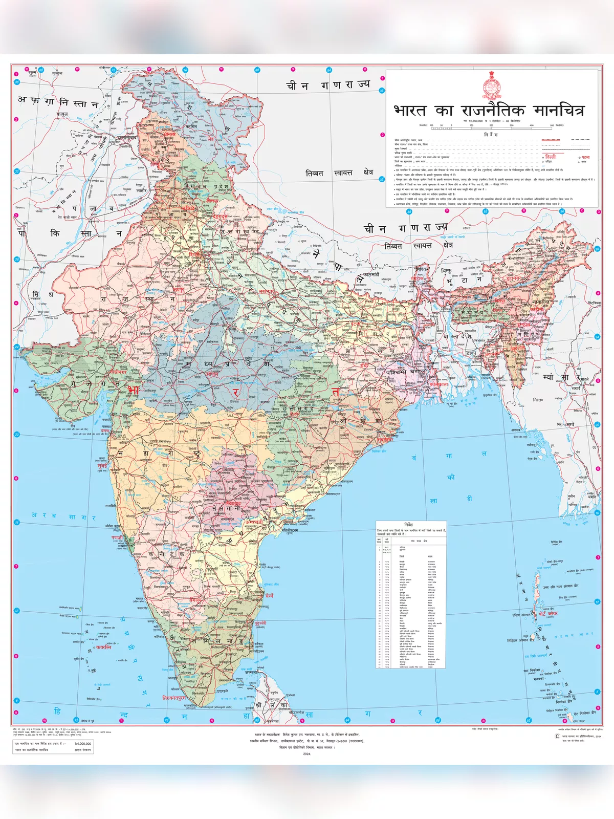
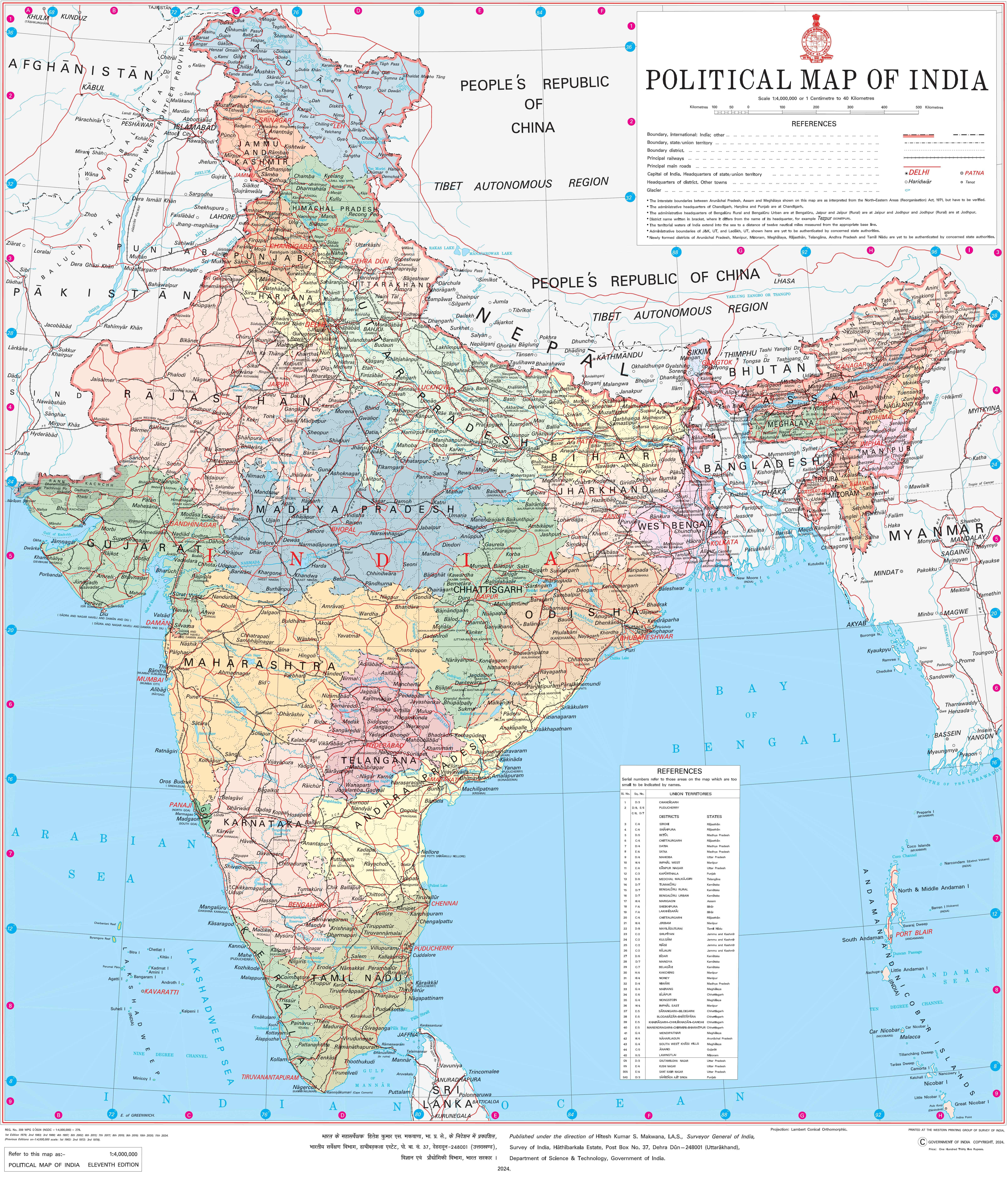
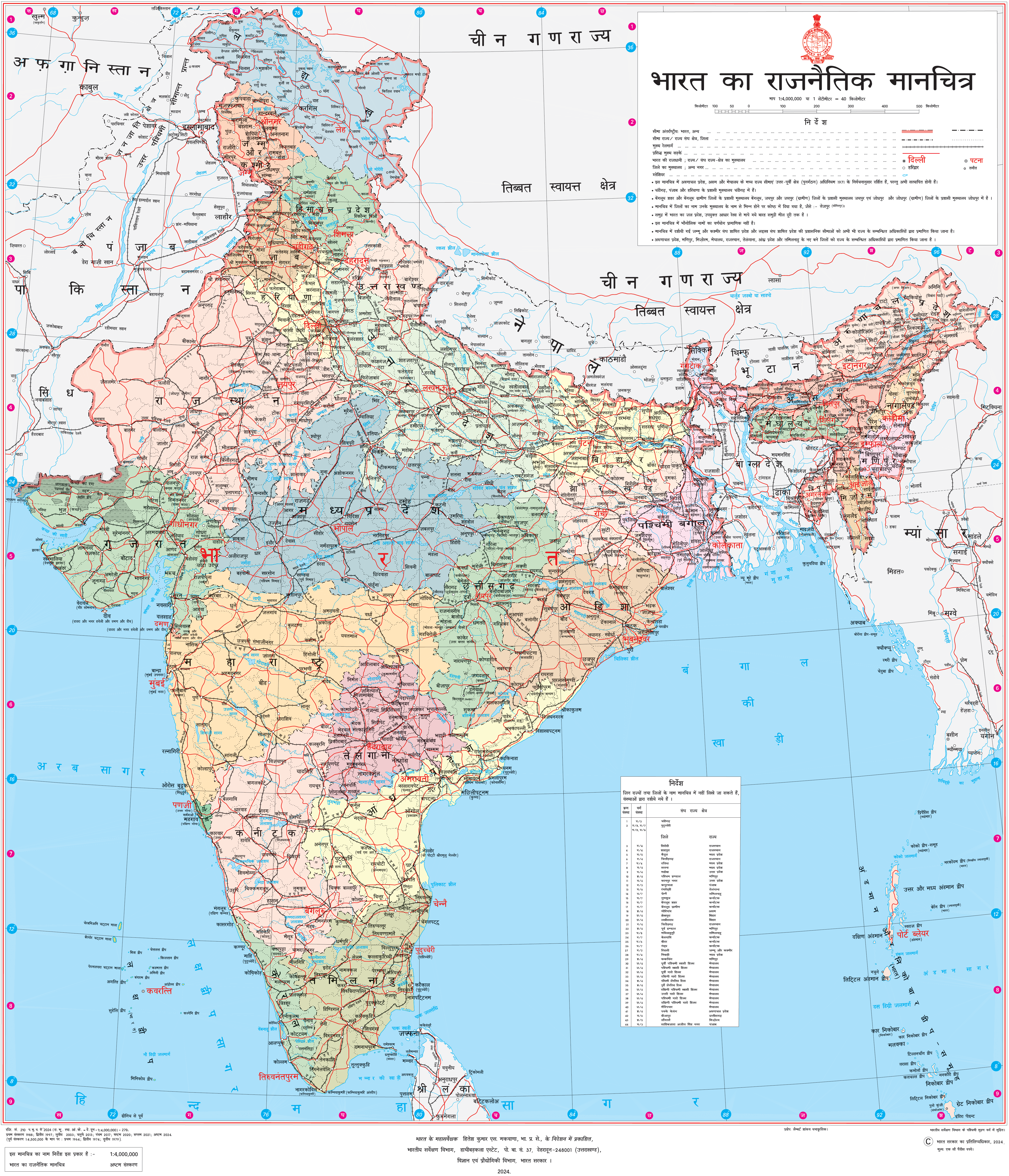
India’s Political map (भारत का राजनैतिक मानचित्र) shows all the states and union territories of India along with their capital cities. The Indian naval hydro-graphic charts along with the mainland coastline include 43% of sandy beaches, 36% of mudflats, marshy shores 10%, and rocky shores 11%.
This PDF of Indian Political Map 2026 contains the map in Hindi and English Languages.
India is the second most populated country in the world and the world’s largest democracy. The country’s coastline measures 7,517 kilometers in length, out of which 5,423 kilometers belong to peninsular India, and 2,094 kilometers belong to Andaman, Nicobar, and Lakshadweep island chains. Eastern India includes the states of Bihar, Jharkhand, Odisha, West Bengal, and the union territory Andaman and Nicobar Islands.
Latest Political Map of India – भारत का राजनैतिक मानचित्र 2026
The western region of India covers a total area of 508,052 sqkm. Some popular states of western India are Gujarat, Goa and Maharashtra Union Territory of Dadra & Nagar Haveli and Daman & Diu. Mumbai, the financial capital of India, is the capital city of Maharashtra.
North India is Himachal Pradesh, Uttar Pradesh, Uttarakhand, Punjab, and Haryana with union territories of Delhi (National Capital Territory), Chandigarh Ladakh, and Jammu and Kashmir.
Southern India covers states like Tamil Nadu, Karnataka, Kerala, Andhra Pradesh and Telangana with the union territories of Lakshadweep. and Puducherry.
High Resolution Political Map of India – English
This is the official political map of India issued by the Survey of India department of Indian Government. The high resolution version of this image can be downloaded by clicking on the image itself and the PDF can be downloaded using the below download button or from the official website of Survey of India at surveyofindia.gov.in.
High Resolution Political Map of India – Hindi
Download the High resolution Indian Political Map in Hindi by clicking on the image below.
Uses of Indian Political Map
The Political map of any country or world, in this case India, can be used by professionals in different fields, students, geographic researchers, government administration departments, travelers and many more. Here are some of the most common applications where the political map of India may be used.
- Understanding Geography: A high-resolution political map of India helps people understand the geography of the country. It shows the boundaries of states, cities, and important landmarks like rivers and mountains.
- Educational Purposes: Schools and educational institutions use these maps to teach students about the political divisions of India. It helps students learn about states, capitals, and major cities.
- Travel Planning: Travelers use political maps to plan their trips within India. They can see the locations of different states, cities, and tourist attractions, helping them decide where to go and how to get there.
- Business and Economics: Companies use these maps for market analysis and strategic planning. They can identify potential markets, distribution channels, and areas for expansion based on the political boundaries and demographics of different regions.
- Government and Administration: Government agencies use political maps for administrative purposes. They help in the planning and implementation of various policies, infrastructure projects, and resource allocation across different states and regions.
- Research and Analysis: Researchers and analysts use political maps to study various aspects of India, such as population distribution, economic development, political trends, and social dynamics. The detailed information provided by these maps helps them make informed decisions and draw meaningful conclusions.
Overall, a high-resolution political map of India serves as a valuable tool for education, travel, business, governance, research, and various other purposes, helping people understand and navigate the complexities of the country’s political landscape.
Latest Political Map of India PDF Download using the link given below.