Bihar Map

Bihar Map PDF download free from the direct link given below in the page.

44 Like this PDF
❴SHARE THIS PDF❵ FacebookX (Twitter)Whatsapp
REPORT THIS PDF ⚐

Bihar Map PDF

The Indian state of Bihar is located in Eastern India, bordering Nepal to its North, Jharkhand in the South, West Bengal lies to its East, and Uttar Pradesh in the West. It is popular as the birthplace of Buddhism. The state is considered a great center of learning, power, and culture.

बिहार भारत के उत्तर-पूर्वी भाग के मध्य में स्थित एक प्रसिद्ध ऐतिहासिक राज्य है और इसकी राजधानी पटना है। बिहार का असली नाम मगध हैं। बिहार को पहले प्राचीन इतिहास मे मगध के नाम से जाना जाता था। यह जनसंख्या की दृष्टि से भारत का तीसरा सबसे बड़ा प्रदेश है जबकि क्षेत्रफल की दृष्टि से बारहवां है।

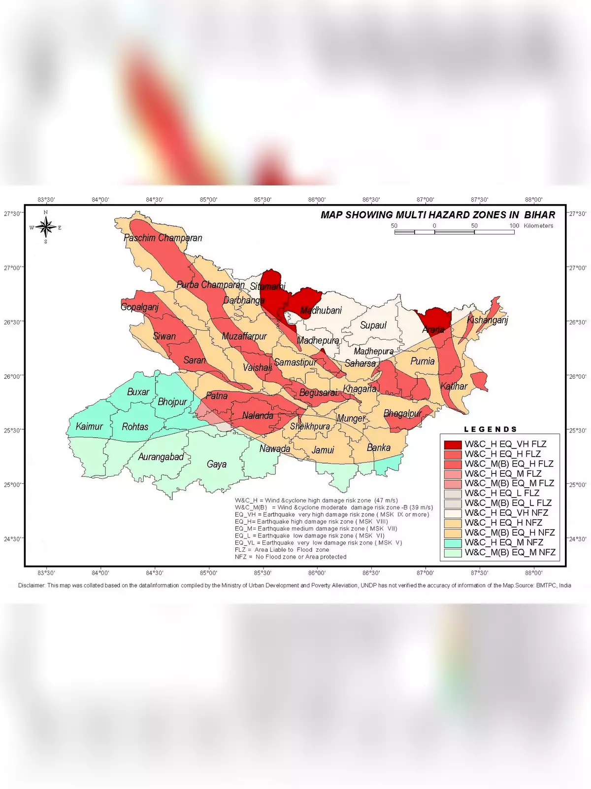
Bihar Map District Map PDF

S No.DistrictHeadquartersPopulation (Census 2011)Sex Ratio (per 1000)Average Literacy
1ArariaAraria281156992153.53%
2ArwalArwal70084392867.43%
3AurangabadAurangabad254007392670.32%
4BankaBanka203476390758.17%
5BegusaraiBegusarai297054189563.87%
6BhagalpurBhagalpur303776688063.14%
7BhojpurArrah272840790770.47%
8BuxarBuxar170635292270.14%
9DarbhangaDarbhanga393738591156.56%
10East ChamparanMotihari509937190255.79%
11GayaGaya439141893763.67%
12GopalganjGopalganj2562012102165.47%
13JamuiJamui176040592259.79%
14JehanabadJehanabad112531392266.80%
15KaimurBhabua162638492069.34%
16KatiharKatihar307102991952.24%
17KhagariaKhagaria166688688657.92%
18KishanganjKishanganj169040095055.46%
19LakhisaraiLakhisarai100091290262.42%
20MadhepuraMadhepura200176291152.25%
21MadhubaniMadhubani448737992658.62%
22MungerMunger136776587670.46%
23MuzaffarpurMuzaffarpur480106290063.43%
24NalandaBihar Sharif287765392264.43%
25NawadaNawada221914693959.76%
26PatnaPatna583846589770.68%
27PurniaPurnia326461992151.08%
28RohtasSasaram295991891873.37%
29SaharsaSaharsa190066190653.20%
30SamastipurSamastipur426156691161.86%
31SaranChhapra395186295465.96%
32SheikhpuraSheikhpura63634293063.86%
33SheoharSheohar65624689353.78%
34SitamarhiSitamarhi342357489952.05%
35SiwanSiwan333046498869.45%
36SupaulSupaul222907692957.67%
37VaishaliHajipur349502189566.60%
38West ChamparanBettiah393504290955.70%

You can download the Bihar Map in PDF format using the link given below.

2nd Page of Bihar Map PDF
Bihar Map

Download Bihar Map PDF

REPORT THISIf the purchase / download link of Bihar Map PDF is not working or you feel any other problem with it, please REPORT IT by selecting the appropriate action such as copyright material / promotion content / link is broken etc. If this is a copyright material we will not be providing its PDF or any source for downloading at any cost.

SIMILAR PDF FILES

  • 2016 West Bengal Assembly Election Result

    A Legislative Assembly election was held in 2016 for the 294 seats (out of 295 seats) of the Vidhan Sabha in the state of West Bengal in India. The India Trinamool Congress under Mamata Banerjee won 211 seats, and thus was reelected with an enhanced majority. 2016 West Bengal Legislative...

  • 508 Railway Stations List

    Prime Minister Narendra Modi is set to virtually lay the foundation stone for the redevelopment of 508 railway stations across India on August 6. The ambitious project, executed under the Amrit Bharat Scheme, aims to enhance passenger amenities and improve railway infrastructure. With an estimated cost of ₹24,470 crore, the...

  • Ajmer District Villages Names List Hindi

    Ajmer is one of the major and oldest cities in the Indian state of Rajasthan and the centre of the eponymous Ajmer District. Ajmer is surrounded by the Aravalli Mountains. Ajmer had been a municipality since 1869. Ajmer has been selected as one of the heritage cities for the HRIDAY...

  • All India State Wise Covid Hospitals List & Helpline Numbers

    Here is the complete and latest list of Covid hospitals in India (State-Wise) along with the helpline numbers. State Wise Covid Hospitals List & Helpline Numbers State/UT Helpline Number COVID Facilities / Hospitals List Andaman & Nicobar Islands 03192-232102 https://dhs.andaman.gov.in/NewEvents/249.jpeg Andhra Pradesh 0866-2410978 (District Wise Helpline Numbers) http://hmfw.ap.gov.in/COVID-19%20Hospitals.pdf Arunachal Pradesh...

  • Alwar District Villages Names List Hindi

    Alwar is a city in the northern Indian state of Rajasthan. Alwar City Palace, from 1793, blends architectural styles and has marble pavilions on lotus-shaped bases in its courtyard, plus a museum with rare manuscripts. It’s next to the marble and sandstone Moosi Maharani Chhatri shrine. Alwar District have 2061...

  • Amrit Bharat Station Scheme List

    Prime Minister Narender Modi announces a new scheme for the redevelopment of 508 stations under the Amrit Bharat Station Scheme.  The redevelopment project, which will cost Rs 24,470 crore, will install modern passenger amenities apart from ensuring a well-designed traffic circulation, inter-modal integration and well-designed signage for the guidance of...

  • Baswada District Villages Names List

    Banswara is a city in Banswara District in south Rajasthan in India. It is named for the “bans” or bamboo forests in the area. It is also known as ‘City of Hundred Islands’ or ‘CherraPoonji of Rajasthan’, due to highest rain in Rajasthan and presence of numerous islands on the...

  • Bihar COVID-19 Containment Zones List Hindi

    According to the Ministry of Health, a Covid-19 containment zone refers to the area where positive cases of coronavirus are found, and here is the PDF list of containment zone updated 4th May 2020. Containment zones are created to map the local transmission of the disease and prevent the contagion...

  • Bihar Elections 2020 Dates / Schedule

    Schedule for General Election to the Legislative Assembly of Bihar 2020 has been announced by the Election Commission of India. The elections in Bihar will be held in three phases starting on 28th October 2020. Bihar Election Dates 2020 Poll Events Phase-I (71 ACs) Phase-II (94 ACs) Phase-III (78 ACs)...

Leave a Reply

Your email address will not be published. Required fields are marked *