Download PDF of Nepal Map with District from the link available below in the article, Nepal Map with District PDF free or read online using the direct link given at the bottom of content.
Nepal Map with District PDF read online or download for free from the link given at the bottom of this article.
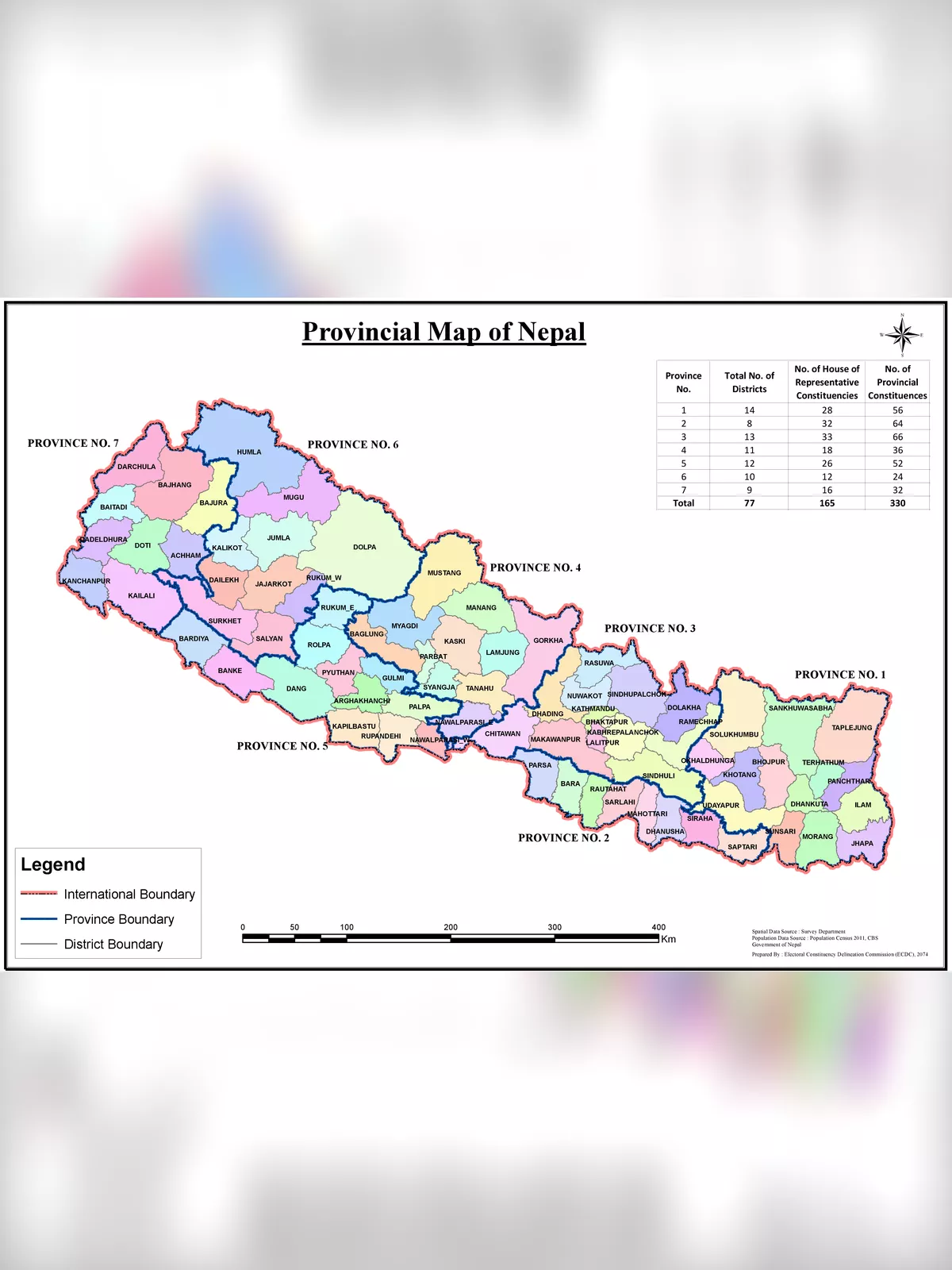
Nepal Map with Districts are second level of administrative divisions after provinces. Districts are subdivided in municipalities and rural municipalities. There are seven provinces and 77 districts in Nepal.
After the state’s reconstruction of administrative divisions, Nawalparasi District and Rukum District were divided into Parasi District (officially Nawalparasi (West of Bardaghat Susta) District) and Nawalpur District (officially Nawalparasi (East of Bardaghat Susta) District), and Eastern Rukum District and Western Rukum District respectively.
Nepal Map with District
Districts Before 1956
East No. 1
East No. 2
East No. 3
East No. 4
Dhankuta
Ilam
Bara
Mahottar-Sarlahi
Saptari
Biratnagar
Jhapa
Chisapanigadhi
Udayapur
West No. 1
West no. 2
West no. 3
West no. 4
Palpa
Pyuthan
Salyan
Jumla
Dailekh
Doti
Bajhang
Baitadi
Dadeldhura
Palhi-majhkhand
Khajhani sivaraj
Dang-deukhuri
Banke-bardiya
Kailali-kanchanpur
Kathmandu valley
Districts from 1956 to 1962
Mechi
Biratnagar
Taplejung
Dhankuta
Bhojpur
Hanumannagar
Sagarmatha
Janakpur
Dolakha
Chautara
Kathmandu
Bara
Trishuli
Rapti
Gorkha
Pokhara
Syangja
Lumbini
Baglung
Gulmi
Kapilavastu
Pyuthan
Humla
Karnali
Jajarkot
Salyan
Dailekh
Nepalganj
Bajhang
Doti
Dhangadhi
Mahakali
You can download the Nepal Map with District PDF using the link given below.
Download link of PDF of Nepal Map with District
REPORT THISIf the purchase / download link of Nepal Map with District PDF is not working or you feel any other problem with it, please REPORT IT by selecting the appropriate action such as copyright material / promotion content / link is broken etc. If this is a copyright material we will not be providing its PDF or any source for downloading at any cost.