India Map with States & Capital 2026 - Summary
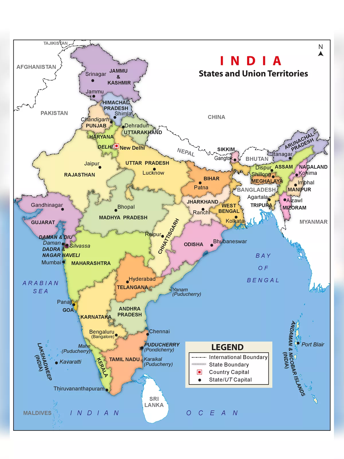
India is located in southern Asia. It is bordered by the Arabian Sea, Laccadive Sea, and the Bay of Bengal to the south; Bhutan, Nepal, China, and Pakistan to the north; and Bangladesh and Myanmar (Burma) to the east.
The India Political map shows all the states and union territories of India along with their capital cities. It comprises a total of 28 states along with eight union territories.
| States and Capitals of India 2026 (Updated) | |||
|---|---|---|---|
| S. No | States Name | Capital | Founded on |
| 1 | Andhra Pradesh | Hyderabad (Proposed Capital Amaravati) | 1 Nov. 1956 |
| 2 | Arunachal Pradesh | Itanagar | 20 Feb. 1987 |
| 3 | Assam | Dispur | 26 Jan. 1950 |
| 4 | Bihar | Patna | 26 Jan. 1950 |
| 5 | Chhattisgarh | Raipur | 1 Nov. 2000 |
| 6 | Goa | Panaji | 30 May. 1987 |
| 7 | Gujarat | Gandhinagar | 1 May. 1960 |
| 8 | Haryana | Chandigarh | 1 Nov. 1966 |
| 9 | Himachal Pradesh | Shimla | 25 Jan. 1971 |
| 10 | Jharkhand | Ranchi | 15 Nov. 2000 |
| 11 | Karnataka | Bengaluru (formerly Bangalore) | 1 Nov. 1956 |
| 12 | Kerala | Thiruvananthapuram | 1 Nov. 1956 |
| 13 | Madhya Pradesh | Bhopal | 1 Nov. 1956 |
| 14 | Maharashtra | Mumbai | 1 May. 1960 |
| 15 | Manipur | Imphal | 21 Jan. 1972 |
| 16 | Meghalaya | Shillong | 21 Jan. 1972 |
| 17 | Mizoram | Aizawl | 20 Feb. 1987 |
| 18 | Nagaland | Kohima | 1 Dec. 1963 |
| 19 | Odisha | Bhubaneswar | 26 Jan. 1950 |
| 20 | Punjab | Chandigarh | 1 Nov. 1956 |
| 21 | Rajasthan | Jaipur | 1 Nov. 1956 |
| 22 | Sikkim | Gangtok | 16 May. 1975 |
| 23 | Tamil Nadu | Chennai | 26 Jan. 1950 |
| 24 | Telangana | Hyderabad | 2 Jun. 2014 |
| 25 | Tripura | Agartala | 21 Jan. 1972 |
| 26 | Uttar Pradesh | Lucknow | 26 Jan. 1950 |
| 27 | Uttarakhand | Dehradun (Winter), Gairsain (Summer) | 9 Nov. 2000 |
| 28 | West Bengal | Kolkata | 1 Nov. 1956 |
| Union Territories and Capitals | |||
| Union Territories Names | Capital | Founded on | |
| 29 | Andaman and Nicobar Islands | Port Blair | 1 Nov. 1956 |
| 30 | Chandigarh | Chandigarh | 1 Nov. 1966 |
| 31 | Dadra & Nagar Haveli and Daman & Diu | Daman | 26 Jan. 2020 |
| 32 | Delhi | New Delhi | 9 May. 1905 |
| 33 | Jammu and Kashmir | Srinagar (Summer) , Jammu (Winter) | 31-Oct-19 |
| 34 | Lakshadweep | Kavaratti | 1 Nov. 1956 |
| 35 | Puducherry | Pondicherry | 1 Nov. 1954 |
| 36 | Ladakh | Leh | 31-Oct-19 |
Download the India Map with States & Capital 2026 PDF using the link given below.