India Map Telugu - Summary
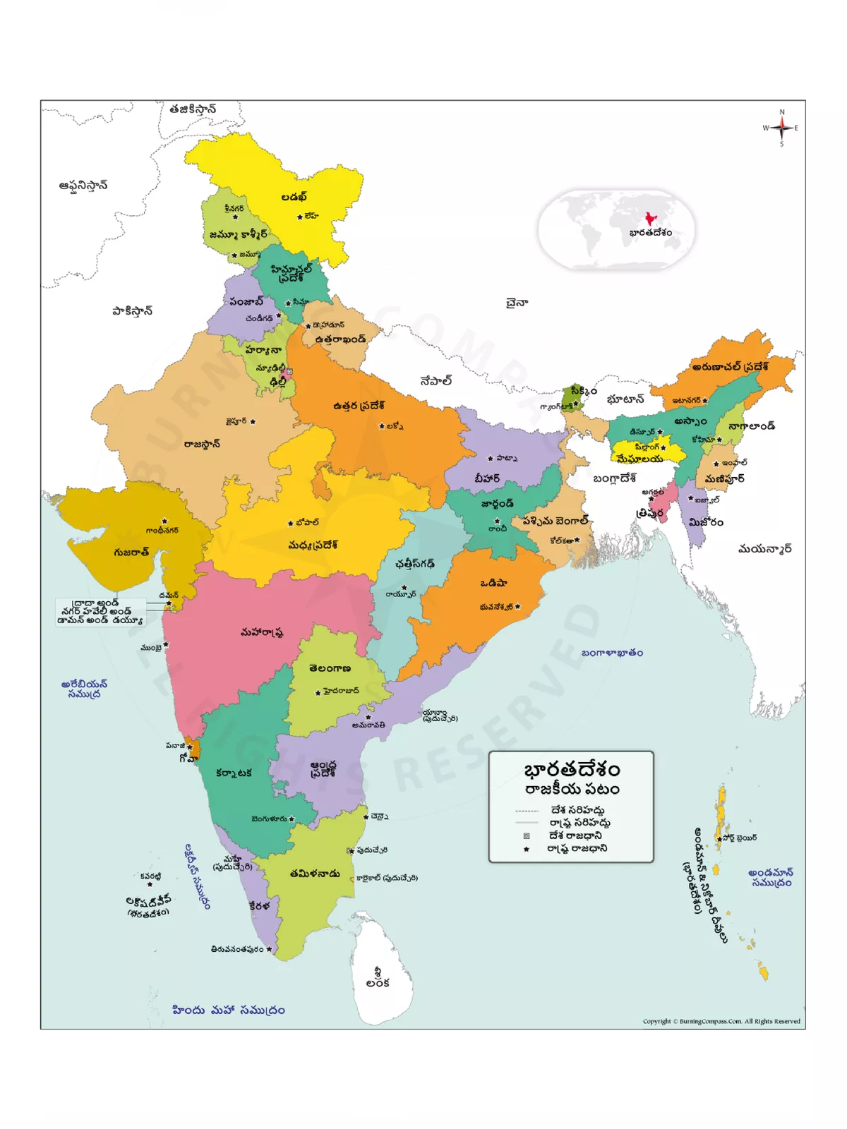
భారతదేశంలో రాష్ట్రాలు మరియు రాజధానులు: ఈ వ్యాసంలో, భారతదేశంలోని రాష్ట్రాలు మరియు రాజధాని గురించి అన్ని వివరాలను మీరు తెలుసుకుంటారు. భారతదేశంలో 28 రాష్ట్రాలు మరియు 8 కేంద్రపాలిత ప్రాంతాలు ఉన్నాయి.
మొత్తం ప్రపంచంలోనే రెండవ అత్యంత ప్రజాదరణ పొందిన దేశం భారతదేశం. ఇది ప్రపంచవ్యాప్తంగా 7 వ అతిపెద్ద దేశంగా పరిగణించబడుతుంది. ఇంత పెద్ద దేశం కావడంతో, దేశ కార్యకలాపాలను నిర్వహించడం కష్టమవుతుంది. భారత రాజ్యాంగం కేంద్రానికి తగిన విధంగా దేశాన్ని వివిధ రాష్ట్రాలుగా మరియు కేంద్రపాలిత ప్రాంతాలుగా విభజించే హక్కును కల్పించింది. States and Capitals of India గురించి మరింత వివరంగా తెలుసుకుందాం.
India Map Telugu – States and Capital of India
| క్రమ సంఖ్య | రాష్ట్రాల పేర్లు | రాజధానులు | ఏర్పడిన తేది |
|---|---|---|---|
| 1 | ఆంధ్రప్రదేశ్ | అమరావతి | 1 Nov, 1956 |
| 2 | అరుణాచల్ ప్రదేశ్ | ఇటానగర్ | 20 Feb, 1987 |
| 3 | అస్సాం | దిస్పూర్ | 26 Jan, 1950 |
| 4 | బీహార్ | పాట్న | 26 Jan, 1950 |
| 5 | ఛత్తీస్ఘడ్ | రైపూర్ | 1 Nov, 2000 |
| 6 | గోవా | పనాజి | 30 May, 1987 |
| 7 | గుజరాత్ | గాంధీనగర్ | 1 May, 1960 |
| 8 | హర్యానా | చండీఘర్ | 1 Nov, 1966 |
| 9 | హిమాచల్ ప్రదేశ్ | షిమ్ల | 25 Jan, 1971 |
| 10 | ఝార్ఖాండ్ | రాంచి | 15 Nov, 2000 |
| 11 | కర్ణాటక | బెంగళూరు | 1 Nov, 1956 |
| 12 | కేరళ | తిరువనంతపురం | 1 Nov, 1956 |
| 13 | మధ్యప్రదేశ్ | భోపాల్ | 1 Nov, 1956 |
| 14 | మహారాష్ట్ర | ముంబై | 1 May, 1960 |
| 15 | మణిపూర్ | ఇంఫాల్ | 21 Jan, 1972 |
| 16 | మేఘాలయ | షిల్లంగ్ | 21 Jan, 1972 |
| 17 | మిజోరాం | ఐజ్వాల్ | 20 Feb, 1987 |
| 18 | నాగాలాండ్ | కొహిమ | 1 Dec, 1963 |
| 19 | ఒడిశా | భువనేశ్వర్ | 26 Jan, 1950 |
| 20 | పంజాబ్ | చండీగర్ | 1 Nov, 1956 |
| 21 | రాజస్తాన్ | జైపూర్ | 1 Nov, 1956 |
| 22 | సిక్కిం | గాంగ్టక్ | 16 May, 1975 |
| 23 | తమిళనాడు | చెన్నై | 26 Jan, 1950 |
| 24 | తెలంగాణా | హైదరాబాద్ | 2 Jun, 2014 |
| 25 | త్రిపుర | అగర్తల | 21 Jan, 1972 |
| 26 | ఉత్తరప్రదేశ్ | లక్నో | 26 Jan, 1950 |
| 27 | ఉత్తరాఖండ్ | డెహ్రాడూన్ (Winter) గైర్సాయిన్ (Summer) | 9 Nov, 2000 |
| 28 | పశ్చిమ బెంగాల్ | కలకత్తా | 1 Nov, 1956 |
భారతదేశంలోని మొత్తం రాష్ట్రాలు / కేంద్రపాలిత ప్రాంతాలు మరియు వారి రాజధానుల గురించి చాలా మందికి తెలియదు. ఈ వ్యాసంలో, మేము మీకు రాష్ట్రాలు మరియు భారత రాజధానులపై తాజా సమాచారాన్ని ఇస్తున్నాము. భారతదేశంలో ప్రస్తుతం మొత్తం 28 రాష్ట్రాలు మరియు 8 కేంద్రపాలిత ప్రాంతాలు ఉన్నాయి. భారతదేశంలోని ప్రతి రాష్ట్రానికి పరిపాలనా, శాసన మరియు న్యాయ రాజధాని ఉంది, కొన్ని రాష్ట్రాలు మూడు విధులు ఒకే రాజధాని నుండి నిర్వహించబడతాయి. ప్రతి రాష్ట్రాన్ని ఒక ముఖ్యమంత్రి పరిపాలిస్తారు. ఇక్కడ మేము భారత రాష్ట్రాలు, కేంద్రపాలిత ప్రాంతాలు మరియు వాటి రాజధానుల జాబితాను వివరిస్తాము.
You can download the India Map Telugu PDF using the link given below.