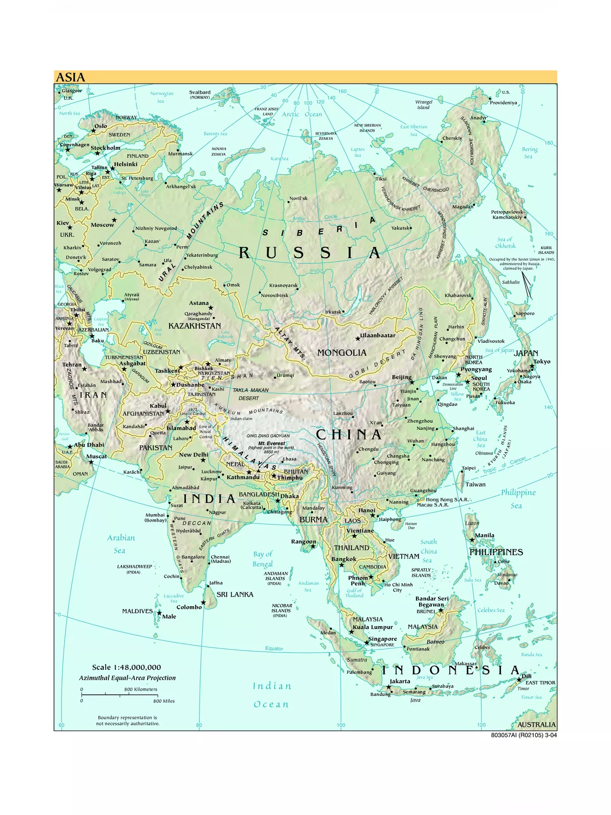
Asia Political Map - Summary
Asia is the largest continent in the world, covering nearly one-third of Earth’s landmass and lying mainly north of the equator, with just a few Southeast Asian islands being exceptions. This Asia political map PDF is perfect for anyone looking to understand the geographical layout of this vast continent. Get ready to explore Asia’s rich diversity through this detailed map!
Understanding the Geography of Asia
Asia occupies a significant part of Eurasia, which is the largest continuous landmass on Earth. To include the region, the Malay Archipelago has also been added to Asia. On the west, Asia shares its borders with Europe, marked by the Ural Mountains and the Caspian Sea.
Geographically, Asia is bounded on the east by the Pacific Ocean, to the south by the Indian Ocean, and to the north by the Arctic Ocean. The boundary between Asia and Europe is more of a historical and cultural idea rather than a clear physical division. This distinction has evolved since its early conception in ancient times.
Asia Political Map – High Quality / Printable Political Map of Asia
Asia covers an area of about 49,700,000 km² (19,189,277 sq mi), which is approximately 30% of the total land area on Earth. As of 2020, Asia’s population exceeds 4.6 billion people, making up around 60% of the global population.
The highest point in Asia is Sagarmatha (also known as Chomolungma or Mount Everest) at an impressive height of 8,848 meters (29,028 feet), located on the border between China and Nepal.
Additionally, the largest lakes in Asia include the Caspian Sea (a saltwater lake) at 371,000 km² (143,250 sq mi) and Ozero Baikal or Lake Baikal (31,500 km²) in Siberia, which is the largest freshwater lake in the world by volume.
Asian Sub-regions Depicted on the Map
- North Asia: Often referred to as Northern Asia, this region comprises the Russian Federation east of the Ural Mountains, including the Ural region, Siberia, and the Russian Far East. North Asia spans an area of 13.1 million km², covering about 77% of Russia’s territory.
- Central Asia: This area includes the ‘stan’ countries, which are former Soviet republics: Kazakhstan, Kyrgyzstan, Tajikistan, Turkmenistan, and Uzbekistan. Some definitions also include Afghanistan in this region.
- South Asia: South Asia consists of the countries of Afghanistan, Bangladesh, Bhutan, India, Maldives, Nepal, Pakistan, and Sri Lanka.
- East Asia: This eastern region of Asia includes nations such as China (along with its special administrative regions of Hong Kong, Macau, and Tibet), Japan, Mongolia, North Korea (Democratic People’s Republic of Korea), South Korea (Republic of Korea), and Taiwan (Republic of China).
You can download the High-Resolution Asia Political Map PDF using the link given below.