Boston Marathon Course Map - Summary
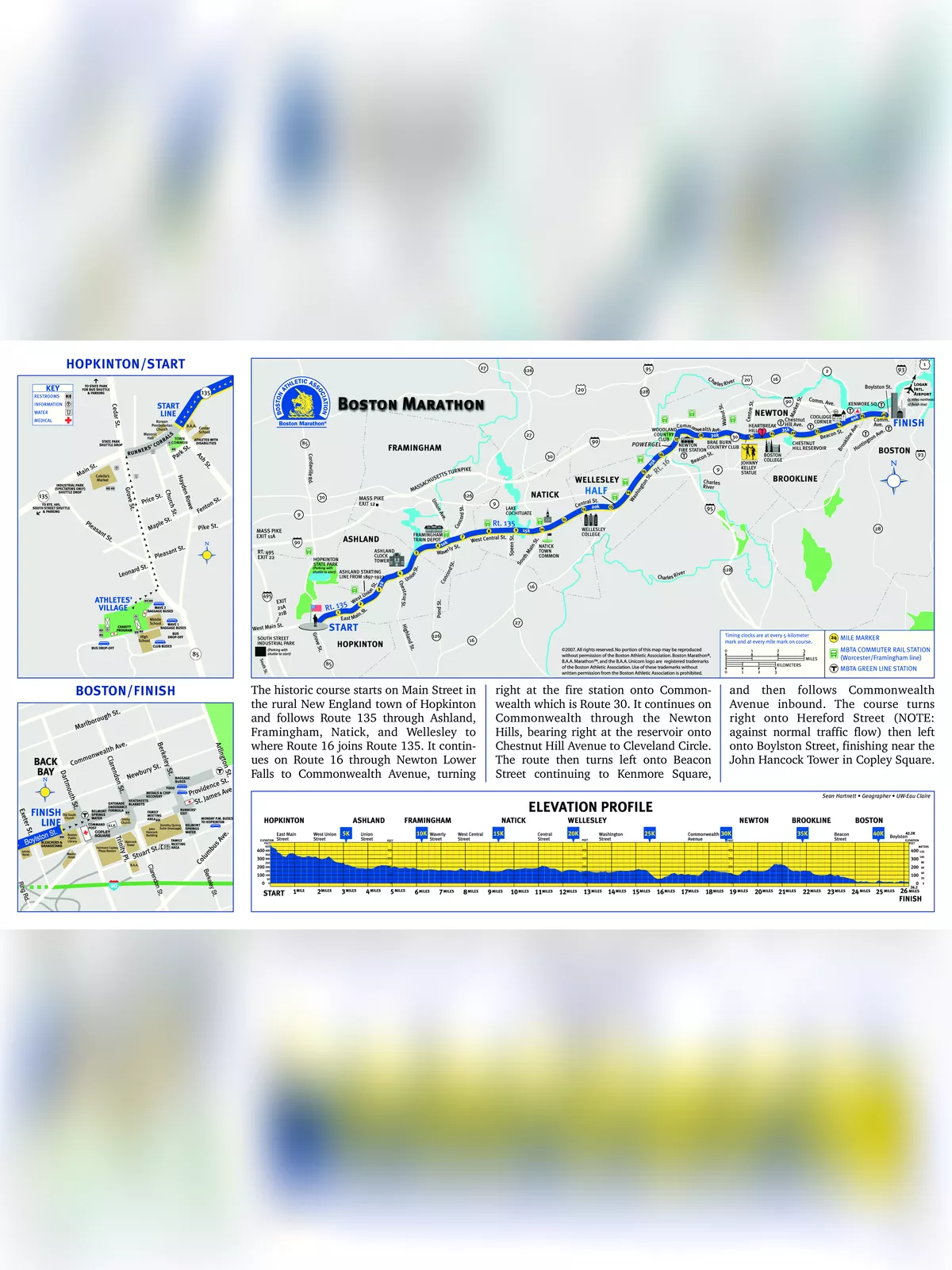
The Boston Marathon Course Map is an essential guide for participants planning to run in one of the most prestigious marathons in the world. This historic course begins on Main Street in the quaint New England town of Hopkinton and follows Route 135 through Ashland, Framingham, Natick, and Wellesley. The journey continues until Route 16 joins Route 135, leading runners through scenic stretches of Newton Lower Falls, where they turn right onto Commonwealth Avenue at the fire station, a landmark along this route.
Details of the Boston Marathon Course
The Boston Marathon Course Map reveals the challenging yet rewarding path through the Newton Hills, where runners will bear right at the reservoir and head onto Chestnut Hill Avenue towards Cleveland Circle. After a left turn onto Beacon Street, they will continue running until they reach Kenmore Square and proceed along Commonwealth Avenue inbound. The exciting finish awaits at Copley Square, near the iconic John Hancock Tower, making for a spectacular end to their marathon journey.
Aid Stations and Support Along the Route
- Poland Spring Water and Lemon Lime Gatorade Endurance Formula stations will be set up along the course beginning at Mile Two.
- Three Maurten Hydrogel stations will be located on the course: mile 11.8 on the Wellesley town line; mile 17 in Newton; and at mile 21.5 just after Boston College.
- Maurten’s Gel 100 (non-caffeinated) and Gel 100 CAF 100 (caffeinated) will be available.
- Digital clocks, positioned at every 5K mark and key mile locations, indicate the unofficial running time from the 9:00 a.m. start only.
- Signage indicates mile and 5K marks.
- Runners unable to finish the race may stop for assistance and direction at one of the 26 medical stations along the course.
- Sweep buses pick up runners at every medical station with drop-off at the Finish Area medical tent.
- Aid stations along the course close at staggered times during the day.
- Finish area facilities officially close at approximately 5:30 p.m.
- Runners still out on the course when officials determine that it is time to reopen the roads (approximately a 14:23 minute-per-mile pace) will be instructed to move to the right side of the road.
- Once roads begin to reopen to vehicular traffic, course infrastructure (such as timing systems, course clocks, medical stations, and water stations) will all begin to close and cease operation.
- Runners on the course after this time accept that they will be on their own and should plan accordingly.
- The B.A.A. will have a team of cyclists in the rear of the pack to assist runners who are at or slower than a 14:23-minute-per-mile pace.
You can easily download the Boston Marathon Course Map PDF using the link given below for your reference.