
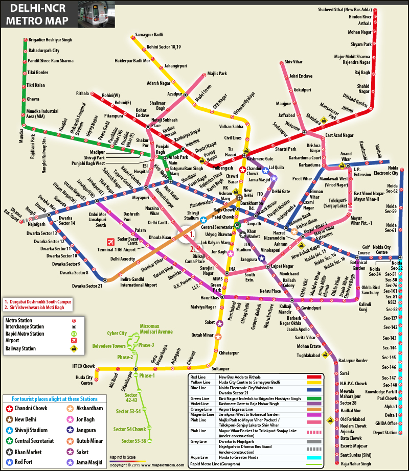
Metro Map Delhi - Summary
The Delhi Metro Map is crucial for anyone wanting to explore and navigate the extensive and lively metro rail network in the National Capital Region. This well-organized Metro Rail system comprises 10 colorful lines that connect 255 stations, covering an impressive total length of 390.14 kilometers (242 miles), which also includes stations from the Gurugram Metro and Noida Metro.
Discover the Delhi Metro System
The Delhi Metro is a rapid transit (MRT) system that efficiently links not only Delhi but also its neighboring cities like Ghaziabad, Faridabad, Gurugram, Noida, Bahadurgarh, and Ballabhgarh. It is the largest and busiest metro system in India and holds the title of the second oldest metro in the country, following the Kolkata Metro.
Advantages of Traveling by Delhi Metro
Using the Delhi Metro is one of the easiest ways to travel around the city. It helps you dodge heavy traffic, and it is also a wallet-friendly option for transportation. Additionally, the trains run frequently, making it simple for you to plan your trips, whether for work or fun.
If you want to keep the Delhi Metro Map accessible at all times, it is available in a convenient PDF format for easy download. Just click the link below to download the PDF of the Metro Map and start your journey through the bustling streets of Delhi!
Delhi Metro Map Overview
The system features a blend of underground, at-grade, and elevated stations, utilizing both broad-gauge and standard-gauge rails. Delhi Metro runs over 2,700 trips each day, beginning around 06:00 and concluding at 23:00.
Delhi Metro also connects with the Rapid Metro Gurugram (using a shared ticketing system) and the Noida Metro. On 22 October 2019, the DMRC (Helpline – 155370) took over operations of the financially troubled Rapid Metro Gurgaon.
List of Key Delhi Metro Stations
- Noida Electronic City
- Noida Sector 62
- Noida Sector 59
- Noida Sector 61
- Noida Sector 52
- Noida Sector 34
- Noida City Centre
- Noida Golf Course
- Botanical Garden
- Noida Sector 18
- Noida Sector 16
- Noida Sector 15
- New Ashok Nagar
- Mayur Vihar Extension
- Mayur Vihar-I
- Akshardham
- Yamuna Bank
- Indraprastha
- Pragati Maidan
- Mandi House
- Barakhamba Road
- Rajiv Chowk
- R K Ashram Marg
- Jhandewalan
- Karol Bagh
- Rajendra Place
- Patel Nagar
- Shadipur
- Kirti Nagar
- Moti Nagar
- Ramesh Nagar
- Rajouri Garden
- Tagore Garden
- Subhash Nagar
- Janakpuri East
- Janakpuri West
- Uttam Nagar East
- Uttam Nagar West
- Nawada
- Dwarka Mor
- Dwarka
- Dwarka Sector 14
- Dwarka Sector 13
- Dwarka Sector 12
- Dwarka Sector 11
- Dwarka Sector 10
- Dwarka Sector 9
- Dwarka Sector 8
- Dwarka Sector 21
Delhi-NCR Metro Route Map
 Download Delhi Metro Map PDF[/caption>
You can easily download the Delhi Metro Map in PDF format using the link provided below.